


Voting District CM, Transylvania County, North Carolina
About
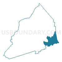
Outline

Summary
| Unique Area Identifier | 641495 |
| Name | Voting District CM |
| County | Transylvania County |
| State | North Carolina |
| Area (square miles) | 24.08 |
| Land Area (square miles) | 23.74 |
| Water Area (square miles) | 0.34 |
| % of Land Area | 98.58 |
| % of Water Area | 1.42 |
| Latitude of the Internal Point | 35.16114250 |
| Longtitude of the Internal Point | -82.63354660 |
Maps


Graphs
Select a template below for downloading or customizing gragh for Voting District CM, Transylvania County, North Carolina


Neighbors
Neighoring Voting District (by Name) Neighboring Voting District on the Map
- Voting District CB, Henderson County, NC
- Voting District DR, Transylvania County, NC
- Voting District EF, Transylvania County, NC
- Voting District GR, Henderson County, NC
- Jennings Mill Voting District, Greenville County, SC
- Voting District LR, Transylvania County, NC
- Voting District WC, Transylvania County, NC
Top 10 Neighboring County Subdivision (by Population) Neighboring County Subdivision on the Map
- Slater-Marietta CCD, Greenville County, SC (4,949)
- Dunns Rock township, Transylvania County, NC (4,877)
- Green River township, Henderson County, NC (4,695)
- Crab Creek township, Henderson County, NC (4,558)
- Little River township, Transylvania County, NC (2,545)
Top 10 Neighboring Unified School District (by Population) Neighboring Unified School District on the Map
- Greenville County School District, SC (466,178)
- Henderson County Schools, NC (106,740)
- Transylvania County Schools, NC (33,090)
Top 10 Neighboring State Legislative District Lower Chamber (by Population) Neighboring State Legislative District Lower Chamber on the Map
Top 10 Neighboring State Legislative District Upper Chamber (by Population) Neighboring State Legislative District Upper Chamber on the Map
- State Senate District 48, NC (193,127)
- State Senate District 50, NC (175,858)
- State Senate District 5, SC (115,205)
Top 10 Neighboring 111th Congressional District (by Population) Neighboring 111th Congressional District on the Map
Top 10 Neighboring Census Tract (by Population) Neighboring Census Tract on the Map
- Census Tract 9320, Henderson County, NC (4,542)
- Census Tract 9604.02, Transylvania County, NC (4,269)
- Census Tract 9604.01, Transylvania County, NC (4,127)
- Census Tract 9319.02, Henderson County, NC (2,927)
- Census Tract 41.02, Greenville County, SC (963)
Top 10 Neighboring 5-Digit ZIP Code Tabulation Area (by Population) Neighboring 5-Digit ZIP Code Tabulation Area on the Map
- 28739, NC (19,786)
- 28712, NC (19,347)
- 28768, NC (6,813)
- 29661, SC (5,648)
- 28790, NC (3,205)
- 29635, SC (1,254)
- 28718, NC (553)